Summary Formats
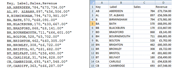
This is the simplest format containing totals for each area. Shown below is the contents of a Postal Area CSV text file and what it looks like in a spreadsheet.

- Choose the level of your summary data
-
We support summary formats for postcode area data, postcode district data and postcode sector data.
- Start Simple
-
It is best to start with data at the Postal Area level as there are only 124 rows. One row for each Postal Area.
- Key Column
-
Every row must start with a unique column called Key. For example for Postal Area this would be 'SW' or 'HG'.
The Key column must contain a code for a Postal Area, District or Sector.
A Key is unique so should appear on only 1 row. If it is a Postal Area file then there should not be more than one row with a key of 'SW'.
- One Level in each file
-
Do not mix area, districts and sectors together. A file should only contain data for 1 level.
All keys should be Postal Area keys, or all District keys, or all Sector keys.
- Label Column (Optional)
-
If there is a label column then it must appear after the key and before any data columns.
If present then it must be called 'Label' otherwise the system will try and plot it as data.
It will be ignored by the system when uploaded, so it is purely for your own use.
- Add Numeric Data Columns
-
You can add your data columns to the right of the key and label columns.
Make sure that each column has a unique name and is not called 'Key' or 'Label'.
Ensure that the data for each field is enclosed in quotes (otherwise commas in formatted numbers/currency may corrupt the file)
Format any numbers prior to uploading. If you want numbers to 2 decimal places then make them 2 decimal places in the file.
Any of the numeric fields/columns that you add can be plotted on a map.